
Volume 1: Mastering the Alpine Skies
The Call of the Alps: An Introduction
There is perhaps no place on Earth where the marriage of technology and nature feels more profound than in the heart of the Swiss Alps. Imagine standing on a high ridge near the Eiger: the crisp mountain air filling your lungs, and as you launch your drone, the propellers hum a rhythmic melody against the silence of the peaks. Suddenly, you are seeing the world from a perspective once reserved only for eagles.
However, beneath this breathtaking beauty lies a complex web of regulations. Switzerland is a country of precision—not just in its watches, but in its airspace. To fly here is to enter a highly structured environment where safety, privacy, and respect for nature are paramount.
Welcome to the very first installment of The Global Drone Guide. We are on a mission to explore the skies of every nation, providing you with the essential intel you need to become a responsible, world-class pilot.
1. Navigating the Invisible Boundaries: Where Can You Fly?
The most common mistake visiting pilots make is assuming that "wide open space" means "free to fly." In Switzerland, the sky is a busy shared airspace of rescue helicopters, light aircraft, and delicate ecological zones.
The Digital Compass: The Official Swiss Drone Map
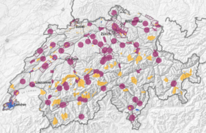
Before powering up your motors, you must consult the official geographical platform provided by the Federal Office of Civil Aviation (FOCA / BAZL).
- The Tool: Always check the Swiss Drone Map (GeoAdmin).
- Airports & CTRs: Flying within 5 km of airport and heliport runways is restricted or requires explicit air traffic control clearance (e.g., Skyguide).
- Wildlife & Nature Reserves: Switzerland strictly enforces environmental preservation. Drones are entirely prohibited in federal game reserves (Jagdbanngebiete) and designated water/migratory bird reserves. Disturbing wildlife can result in severe fines.
Crowds and Privacy
Beyond technical airspace restrictions, you must respect local privacy laws. Flying over assemblies of people (festivals, sports events, packed beaches) is forbidden without special permits. Always maintain a respectful safety buffer around hikers and mountain villages.
2. Mandatory Checkpoints: Registration & Insurance
Since Switzerland aligned its aviation laws with the European Union Aviation Safety Agency (EASA) framework, specific compliance steps apply before taking off.
Checkpoint A: Operator Registration & ID
- Who must register? If your drone weighs 250g or more, OR if it is equipped with a camera/sensor (and is not classified as a pure toy), you must register as an operator.
- The Official Portal: Registration is handled via UAS.gate.
- Identification: Upon registration, you will receive a unique Operator ID. You must physically attach this ID (via a weatherproof sticker or label) to your drone.
Checkpoint B: Mandatory Third-Party Liability Insurance
- The Legal Limit: Mandatory third-party liability insurance coverage of at least 1,000,000 CHF (Swiss Francs) is required for operating drones weighing 250g or heavier.
- The Hidden Trap: Standard private liability policies (Privathaftpflicht) or travel insurances often exclude drone operations.
- What to do: Contact your provider before your trip to request a written certificate confirming coverage for drone operations up to 1 Mio CHF in Switzerland.
3. Pilot Credentials: Training & Categories
Switzerland operates under standard EASA subcategories (A1, A2, A3) in the Open Category:
- Category A1: Applies to sub-250g drones (e.g., DJI Mini series). An online training module is recommended, though not legally mandatory for sub-250g drones unless specified. However, flying over crowds remains strictly forbidden.
- Category A2 & A3: For drones weighing 250g to 25kg. Pilots are required to complete the online training module and pass the theoretical exam on UAS.gate.
4. Alpine Flight Safety: Weather & Climate
In the Swiss Alps, weather dictates flight safety. High-altitude microclimates change with incredible speed.
- Rapid Changes: Sunny valley conditions can turn into heavy wind, dense fog, or freezing rain higher up in under 20 minutes.
- Mountain Wind Channels: Valley floors may seem calm, but mountain passes act as natural wind tunnels. Wind speeds at 2,000 meters are frequently double those at valley level.
- Check MeteoSwiss: Always check localized wind gradients and weather radar via the official MeteoSwiss app before launching.
📱 Must-Have Mobile Apps for Flying in Switzerland
Essential tools to check weather, airspace rules, and alpine safety before launching:
☀️ MeteoSwissOfficial Swiss weather app with localized precipitation radar and wind warnings.
|
🗺️ swiss-u-space / SkyguideSkyguide's airspace awareness tool for real-time local flight restrictions.
|
||||||
🌬️ Windy.comAdvanced wind maps. Essential to check high-altitude wind gusts in mountain passes.
|
🚁 Rega (Alpine Emergency)Swiss Air-Rescue app. Directly transmits coordinates in remote mountain areas if needed.
|
||||||
🚨 AlertswissOfficial Swiss civil protection app for real-time local hazard & emergency alerts.
|
|||||||
💬 Join the Discussion & Help Fellow Pilots!
Planning a drone trip to Switzerland, or have you already captured some alpine shots here? Drop a comment below!
- 🏔️ What region are you planning to fly in?
- ❓ Have any questions about registration or local zone permits?
If you found this guide helpful, please share it with your fellow pilots, on forums, or in your favorite creator communities. Let's keep the skies safe and stunning for everyone!

0 Comments